Tuesday, July 22, 2014

36 Hours in San Francisco

Had a whirlwind visit to Dylan in San Francisco on Sunday and Monday and had a great time. Got to the Embarcadero District where Dylan's conference hotel was located just after noon on Sunday. Spent the next day and a half seeing as much of the city as we could - some with Dylan while he was not at conference events- and some on our own. Hit 21st Amendment Brewing for lunch on Sunday, then Toronado Tap Room in the famed Haight-Ashbury district for a few quick drinks, including the much revered "Pliny the Elder" by Russian River Brewing, that Andre has only had on tap a few times as it is rarely available in the areas we've lived and traveled.

We did miles and miles of walking to take in as many San Francisco sights as possible on Sunday afternoon and Monday morning, including AT&T Park where the SF Giants play. The ball team was out of town and we inadvertently ran into a movie filming there. It was a disaster scene for the upcoming movie "San Andreas" which we assume is an earthquake movie.  We also visited Pier 39 which has been taken over by Sea Lions who lounge on the old wooden piers, and then went on to Fisherman's wharf, the old Ghiradelli chocolate factory and so many other things. We saw plenty of cable cars, although we didn't ride on one, as well as a variety of other electric streetcars, buses and other odd modes of transport up and down the hilly city.

Most of Monday afternoon was spent walking the length of Golden Gate Park which is 3 1/2 miles long (4 1/2 miles if you count the narrow Oak Street strip at the beginning) each way, ending at the Pacific Ocean. It was a stunning park, with an incredible variety of plants, trees, and different environments, including a waterfall, a Bison enclosure and an assortment of other surprising things, like a Dressage Ring, a Japanese Garden, and Dutch Windmills to name a few. The most amazing city park I've ever been in.

All told, we probably walked about 12 miles yesterday, then ended the day driving and then walking across the Golden gate Bridge on our way out of the city. A full, and exciting couple of days.  Here are some photos.


Enjoying a late lunch with Dylan at 21st Amendment


It always seems to be overcast here..


AT&T Park - The San Francisco Giants Baseball Park

Tasty, Salted Pig Parts Anyone??


Pier 39


The first time we've ever seen this sign...


The Pacific Ocean at last !!


That's not us - but YES - we did dip our feet in the Pacific!


Walking onto the Golden Gate Bridge at dusk


View from the bridge at dusk
 
There was an amazing amount of Container Cargo ship activity
 passing under the bridge and out to sea


Saturday, July 19, 2014

Final Yosemite Photos


Sitting here in the Galena Creek Visitor Center with no visitors, as it is pouring out. This is a rare occurrence here this time of year, although afternoon storms have been the pattern here for the past few days. Andre is back at the ranger house doing some van repairs (hopefully inside the van, right now!) so I figured this might be a good time to finally post those last Yosemite photos.

It has been really frustrating this summer living and also working in an area that has such poor communication options. We don't have cell coverage (or very little), cable TV or Internet at the Ranger house and the cell reception and Internet aren't all that great here at the visitor center either. It takes forever to upload photos, so I am going many days without posting, when I really do have lots to share with the world. Or at least my world! That's YOU if you're reading this....

Rather than a long narrative of the second part of our trip, I'll capture it in the photos and a few details with each. Enjoy!

 
Our van looking pretty small in such a "Big" environment

Early morning at Glacier Point - looking down into Yosemite Valley from above
 
Yosemite Valley View


Starting our hike up nearby Sentinel Dome the next morning

Atop Sentinel Dome

Sharing the top of the dome with a crazy squirrel as big as a cat


Survey Marker at the top of Sentinel Dome

One last view of the top of the dome
 
Bridalveil Falls in Yosemite Valley
 
 
Lower Yosemite Falls


The view of El Capitan from the shuttle stop on the road at the base.
There were only three climbers on the face that day because it was so hot.
 We were able to view them through a park telescope
 
 
Then we hiked out to the wall of El Capitan - feeling very small....
 
 
The majesty from the valley
 
 
Beautiful Camping at the higher elevations
 
Our last morning on our way out of the par at Hetch Hetchy Reservoir
(The water source for most of San Francisco)
  
Walked right by this bear munching on raspberries by the shore of the reservoir


The tunnel to the trail at Hetch Hetchy
 
 
GOODBYE YOSEMITE!!

Tuesday, July 8, 2014

Yosemite Part I - a Fortuitous Entrance

If you've ever been to Yosemite National Park, you are aware that the park has a number of different entry points - the most popular being the two entrances on the west and southwest sides of the park through California Rt. 120 and Rt. 140.  Well we didn't come into the park through either of those gates, and the fact that we didn't really shaped our visit in some amazing ways.

One of the often lamented down sides of Yosemite - and other National Parks of equal stature - are the crowds, the lines and the heavy traffic on busy park roads.  At Yosemite, this dynamic is further exacerbated by the relatively small size of Yosemite Valley, arguably it's most popular attraction. This is the part of the park that boasts the most sought after viewing attractions (waterfalls, unusual rock formations, views of El Capitan and Half Dome from the valley floor) as well as most of the campgrounds, hotels, lodges, eating options and shuttle bus service around the long, narrow valley.

Most people start their Yosemite adventure here - and for many they end here as well as they run short of time and never quite make it out to see the many other unique areas of the park. As it turned out, we didn't even see Yosemite valley until almost our third day in! And by then, we had already had so many wonderful experiences in the less traveled areas of the park, that we were more than ready to tackle the crowds in Yosemite Valley with good humor.

We got to the park early on Sunday afternoon, after about a 3-4 hour drive south from Reno, mostly on Nevada Rt. 395.  We stopped to stretch our legs and have lunch in the gateway town of Lee Vining, California, elevation 6,781. It is in Lee Vining where you turn off onto Rt. 120 west to travel on Tioga Road over the Tioga Pass (elev. 9,945 ft) and on through Yosemite's Tioga Pass Entrance.  This is the only entrance to the park from the East and the closest to the Nevada state line.


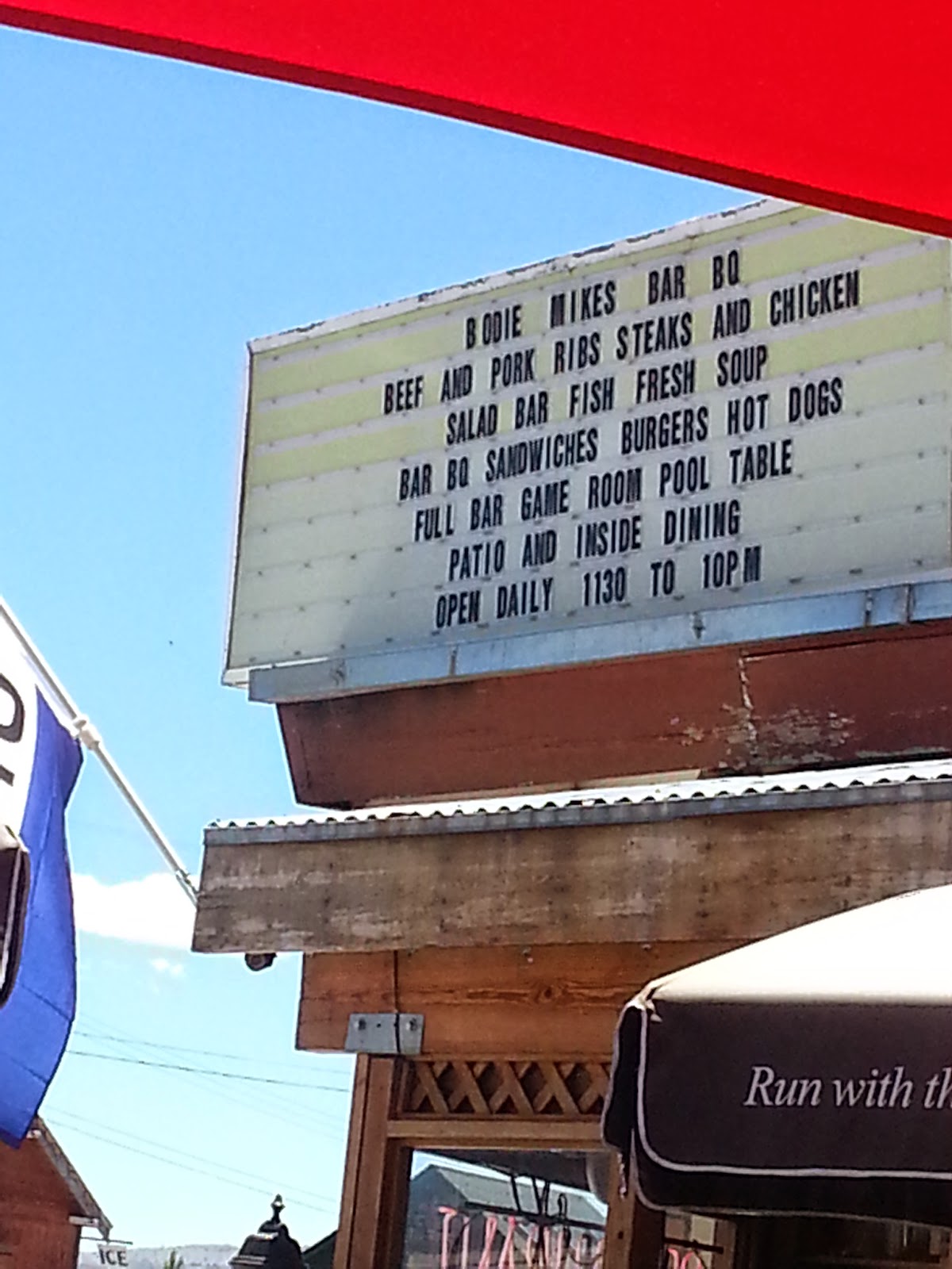
A great lunch at Bodie Mike's BBQ in Lee Vining, CA

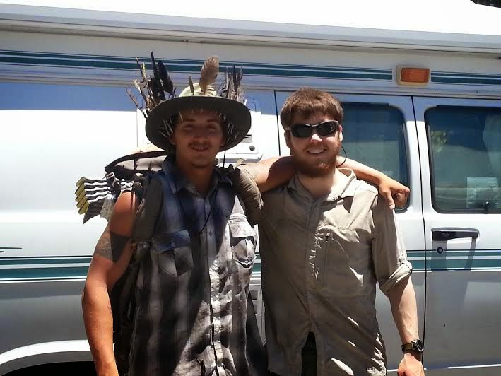
Our entrance to the park was made even more exciting, by a "first" for us. We had a few unexpected passengers in the back of the van!  Just after we made the turn onto Tioga Road heading toward the park, we noticed two young guys on the side of the road with fully loaded backpacks and their thumbs out. We've never picked up hitchhikers before, but having spent a good amount of time backpacking ourselves on trails, we were very familiar with the thru-hiker tradition of hiking down off the trail to get to a town for supplies and then trying to catch a ride back up to the trail.

It turns out they were thru-hikers on the Pacific Crest Trail (PCT) who had done just that and were looking to get back to the trail which runs through Yosemite. So we stuffed them into the back of the van, along with all of their smelly gear and enjoyed talking to them about their hike on the PCT, a roughly 2,600 mile trail that starts at the Mexican border and follows the Pacific crest all the way to the Canadian border. We dropped them off just after we crossed into the park, at a wilderness center and popular hiker meet-up spot not far from the trail. After taking a quick photo of them, we wished them well on the rest of their journey and said goodbye. It was a great way to start our own adventure in the park.


Our happy thru-hiking friends..

The rest of day one was spent enjoying the Tuolumne Meadows section of Yosemite that boasts meandering streams through soft green meadows, hidden lakes and beautiful forests. We camped the first night at the Tuolumne Meadows campground after enjoying a great day of hiking and sightseeing on foot. The visitor center was within walking distance from the campground, as was the John Muir trail and part of the Pacific Crest Trail, so it was a cool place to camp. We enjoyed the campground and especially enjoyed sitting around a campfire again, as we have been in drought-stricken areas for so much of the time that we have been on the road, that a campground that allows campfires was a treat.


That first morning, we were a bit surprised to wake up frigidly cold  - but we were at an elevation of almost 8,500 feet so it really did make sense. As each consecutive day got hotter, we grew to really appreciate the cooler nights camping at the high elevations. Although we would not have had the option of camping in the popular Yosemite Valley anyway (all the campgrounds were booked solid), when we finally got to the valley and it was 102 degrees, we knew we had a better night's sleep than many of those in the most sought-after campgrounds. Here are some photos from that first day.


The next morning we checked out of the campground early and enjoyed a leisurely drive along the 29 mile Tioga Road, stopping frequently to enjoy the many short hikes along the way and scenic pullouts that gave us our first glimpses of some of the stunning rock formations to come.


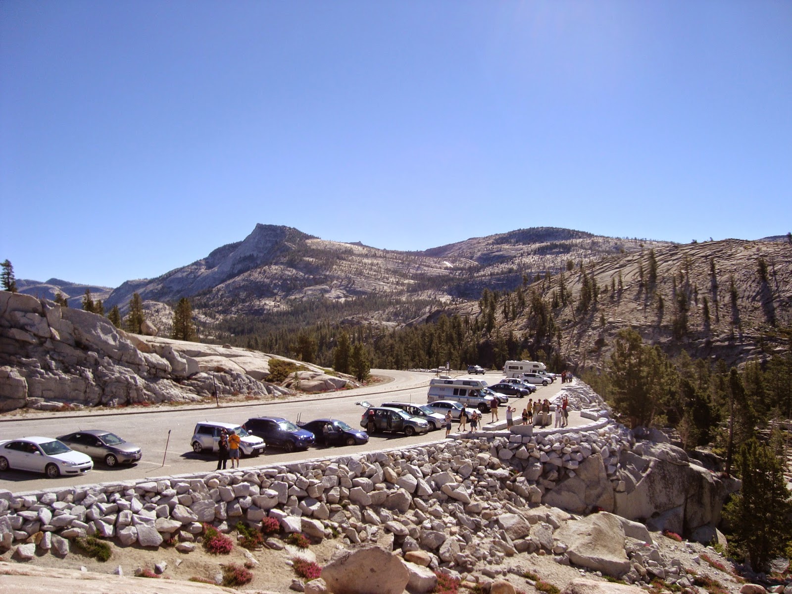
Out of the meadow and into the rocks!

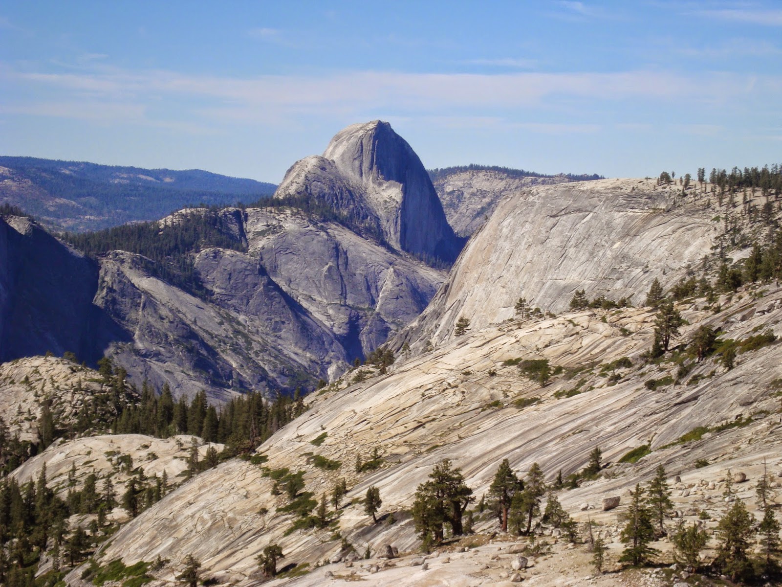
Our first look at Half Dome

One of the greatest things at the above vista turn-out was that there was a telescope set up and we were able to see the long line of hikers making their way up the side of Half Dome! They looked like ants marching. Just one of many amazing sights during those first 36 hours!

Sunday, July 6, 2014

Adjustments – Northern Nevada Style (Andre)


Last year I wrote a blog entry about adjustments we made while living in the west Texas desert. These included things like regular border patrol stops, hundred mile drives to get a pizza, and all the other wonderful and some less wonderful things we got used to at Big Bend.

A truism we have come to learn, and certainly expected, is that when you go to new places you will find new things. It is just that, so far having been at this for just a year and a half or so, it still can be a be a bit of a surprise or smiling reminder that you’re in a new place!

So, some northern Nevada adjustments.


If you notice in the picture above, there is a short vowel sound above the first ‘a’ in ‘Nevada.’ It turns out people here are a bit touchy about the way one pronounces the state name. We, and we think most people out of state, pronounce Nevada as the first ‘a’ being an ‘ah’ sound. Well, they get angry here and have a whole state campaign to correct outsider’s ‘misinformation’. Locals pronounce Nevada as Ne-vadd-a with all short a’s. If you want some help practicing, here’s one of many websites you can go to for this important issue!
http://www.wikihow.com/Pronounce-Nevada


From a distance us on the east coast have heard about the crazy gas prices in California. Unfortunately, and we were a bit surprised by this, while Nevada is not California, it’s pretty close you can leave Reno and be in California in 10 miles. So, when we hear the national average price for a gallon of gas is $3.68, we long for such prices. We have seen prices as high in our travels as $5.49! That was on our way to Yosemite and in a rural area, but trust us gas is high here. The average price is $3.99 to $4.19. But if you look, and we certainly do, we have found such bargain prices as $3.71, $3.89, and such. This is how bad it is, in our travels to Yosemite we were ‘excited’ to find gas for $4.05.


By the way, we have become major fans of gasbuddy.com. If you are not aware, this is a free app you can download to your phone and check gas prices near you or for certain locations. There are other apps for this and if you know a better one, please pass it along.


We like to run as a way to stay in shape and running shoes are easier to carry in the van than a treadmill or elliptical! On our way here, we hoped we would be living near something that was somewhat flat. In Big Bend we were on the side of a mountain which made running a real workout, whether or not you wanted it. Well, when we got here we found out we are living on the ‘Highway to the Clouds’ the tallest year-round maintained pass at over 10,000 feet in the Sierra Nevada Mountains. So much for running paths anything like flat. After a week or so of running down and then back up the mountain road, we decided it was time to buy some trail running shoes!

We live in a ranger house in the woods on US Forest Land with trails literally out our doorstep. (The visitor center that we work at is a short 10 minute walk down one of the trails. We are located about 15 miles south and west of Reno. Reno is at 3,500 feet elevation and we are at 6,500 feet. ) There are more than 30 miles of trails just in the park we work and live in. And trail running is a more fun way to go up and down mountains, at least we think so, than being on busy pavement roads. Fortunately, Sierra Trading Post, a large national mail order company for all things outdoors is located in Reno. We now are proud owners of trail running shoes and do so each morning to start our day!
Certainly there are and will be other adjustments as we continue to experience living in northern Nevada, these are just a few!